 Unknown
 Sunday, August 15, 2010
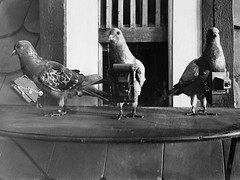 Image by Acid Zebra via FlickrWell in the olden days kids, to get a bird's eye view you literally went to a bird photographer.
 .
After the invention of photography, primitive aerial photographs were made from manned and unmanned balloons, starting in the 1860s, and from tethered kites in the 1880s.
.
.
Then in 1907, Julius Neubronner experimented with pigeons in aerial photography. The pigeons carried small cameras with timers strapped to their chest that snapped a series of aerial images.
.
Soon after, rockets, airplanes, and satelites were developed to give us a bigger picture of the world.
.
And now Google Earth and Google Maps, display satellite images of the Earth's surface to allow everyone a bird's eye view of the world.

(left) Neubranner's pigeon with camera.
(center and right) Aerial photographs taken on pigeon photo flights. Note the wingtips showing in the center top image of the castle.
Related Articles:

Category ›
Quick fun Facts


No comments:
Post a Comment